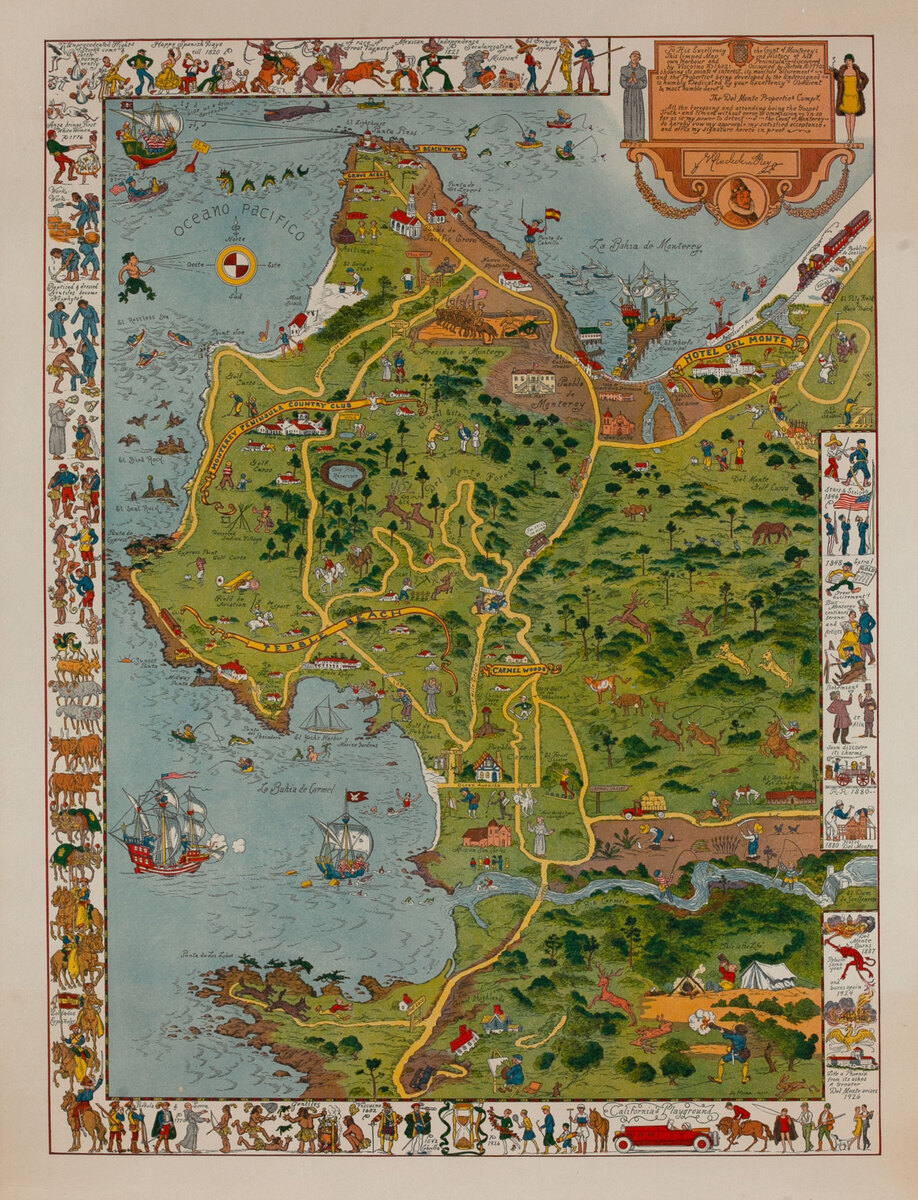
Monterey Peninsula and Del Monte Properties
- 1926
- Jo Mora
-
22 1/2 x 29 inches ~ (55 x 73 cm)$3,200
- Linen backed
Linen backing is the industry standard of conservation. Canvas is stretchered and a sheet of acid free barrier paper is laid down. The poster is then pasted to the acid free paper using an acid free paste. This process is fully reversible and gives support to the poster. A border of linen is left around the poster and can be used by a framer to mount the poster so that nothing touches the poster itself.
The price of this poster includes linen backing.
- Add to Cart Add to Wishlist E-Mail Us About This Poster
This is the first (and probably rarest) map made by Jo Mora. It was commissioned by the Del Monte Company to advertise its property on the Monterey Peninsula.
Decorative pictorial map of the Monterey area of California, among the rarest maps by Jo Mora. The border contains illustrations depicting the history and culture of the area, featuring Spanish soldiers, the burning of Del Monte, cattle, and missionaries. Points of interest are shown throughout, such as Pueblo de Carmel, Monterey Peninsula Country Club, and Hotel del Monte. The numerous comical pictorial illustrations include a mermaid, sea dragon, government ship firing upon another ship carrying alcohol, a man being chased by wolves at Point Lobos (Lobos means "wolves" in Spanish), and a Native American walking away from the skeleton of a teepee labeled "Deserted Indian Village.”
Mora makes a witty reference to the conventions of European maps produced for royal patrons during the Age of Discovery by signing the map with his name followed by "fecit" (Latin for "made by") and including a floridly-written cartouche flanked by drawings of a friar and a flapper: "To His Excellency the Count of Monterey: This limned Map and History of his own Harbour and Peninsula - discovered by Viscaino AD 1602: Occupied by Portola AD 1770: showing its points of interest, its manifold allurements - and the Properties being developed by the Undersigned - is humbly Dedicated by your Excellency's Obedient & most humble Servt's - The Del Monte Properties Compy. All the foregoing and attending being the Gospel Truth - and limned without error or omission - in so far is my power to detect - J - the Count of Monterey - and affix my signature hereto in proof.”
.Joseph "Jo" Mora is one of the foremost pictorial mapmakers of the 20th century. Born in Uruguay, he spent his career in the United States. Like many pictorial mapmakers, Mora had wide-ranging interests and talents -- as an artist who worked in many media, a historian and an author. In 1904, he lived with the Hopi and Navajo Indians in Kearns Canyon, Arizona. He learned their languages and documented the Kachina ceremony and other ethnological information in photographs and paintings. From 1900 to 1949, Mora illustrated several books for children as well as books on California history. He also designed and executed several monuments, memorials and decorations for public buildings in California. His pictorial maps were mainly of California and include maps of the state, Los Angeles, Yosemite, the Grand Canyon, 17 Mile Drive (Pebble Beach), Monterey and Carmel by the Sea. They are very popular with collectors today.